El Niño is the warm phase of the El Niño /La Niña Southern Oscillation (ENSO) that occurs across the tropical Pacific Ocean. Photo: AFP / Science Photo Library
Some Pacific nations are feeling the bite of El Niño through dry conditions, while others in drought get relief through above average rainfall.
The southern Cook Islands has received below average rain for the last six months, despite rain last week.
Meteorological Service director Arona Ngari said dry conditions are affecting the whole of the southern group, including Rarotonga.
"What is normal for us is about 100 to 200 millimetres of rainfall per month, but that has actually gone well below 50 percent of the norm," Ngari said.
The met office had asked the community to conserve water, he said.
In Fiji, Nadi received less than a third of its normal December rain and Suva had received half of the average.
Fiji Meteorological Service acting director Bipen Prakash said even though there had been some rain, it was still significantly less than was normally expected for December - the peak wet season month.
"We expect this trend to continue," Prakash said.
"We expect that generally we will have drier than usual months ahead, we may get a bit of rainfall every now and then with passing troughs of low pressure or tropical cyclones."
Although there had been significantly less rain it had not yet been called a drought ,which, he said, was a decision that involved multiple stakeholders.
NIWA meteorologist Ben Noll said over the last three months Fiji, Tonga, New Caledonia, the Southern Cook Islands and Wallis and Futuna, experienced the driest conditions, while other Pacific nations were experiencing below average rain.
But island groups along the equator, such as Kiribati - which had been in a drought - had now experienced above normal rainfall.
Kiribati Meteorological Service's Ueneta Toorua said all four manual weather stations, including the capital and Tarawa Island, recorded above normal rainfall for the month of December 2023.
"There is a high chance that groundwater and water tanks have been recovered from high rainfall over the last few months," the Kiribati met office chief officer said.
"But noting that rainfall has been significantly low over the last three years, it might also take a while to fully recover, especially in islets where freshwater and water catchments facilities are limited."
Toorua said above average rainfall was expected to continue over the next three months.
'Feeling the effects'
NIWA's Noll said El Niño had so far behaved closely to what had been expected.
"We were anticipating that some of the islands off the equator in the South Pacific, as well as some of the islands in the northwest Pacific, would experience below normal rainfall or a higher chance for below normal rainfall and that has come to fruition.
"There are definitely several islands that are probably feeling the effects of low rainfall over recent months as well as maybe building water stress in some of those islands due to the low rainfall."
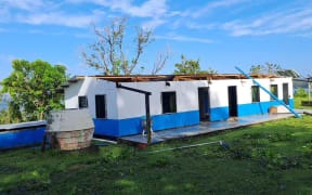
So far, there had been three tropical cyclones this season, with severe tropical cyclone Lola arriving in October before the official start of the cyclone season.
Noll said big El Niño events in 1982/83 and 1997/98 also had early starts to the season.
More cyclones are predicted for the Pacific during El Niño.
He said it was important for the Pacific to be prepared for more cyclones, with the majority reaching the Pacific in February and March.
"We've been about a month now, as of early January, without a cyclone.
"However, cyclone season does run through the end of April in the region.
"There may be a renewed risk for cyclone activity toward the end of the month and that is certainly something that all Pacific islands will need to remain vigilant about."
Noll expected the El Niño conditions would last until at least May.
"There can be a lag between when the ocean moves into neutral and the atmosphere starts to behave in a more of a neutral manner, so it wouldn't surprise me if conditions in the Pacific Ocean in the atmosphere did maintain an El Niño-like flavour into the middle part of 2024," he said.