
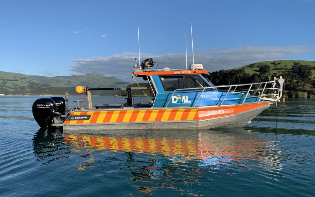
The small aluminium vessel Tupaia is being used to map the seabed of Tūranganui-a-Kiwa/Poverty Bay. Photo: Supplied/LINZ
Around 10,000km will be clocked up by a small aluminium boat criss-crossing the waters of Tūranganui-a-Kiwa this month.
But the long days on board are all worth it for the crew of Tupaia, who are painting a picture of the seabed like it's never been seen before.
Last month, Land Information New Zealand/Toitū Te Whenua (LINZ) embarked on the prodigious task of surveying Poverty Bay with the help of hydrography experts Discovery Marine Limited.
The crew are working up to 8 hours a day on the water to create a 3D seabed model - the first undertaking of its kind, and the most recent effort since the Navy mapped the majority of the area 70 years ago with older technology.
By the time it is complete, they hope the final imagery will be as detailed as if the water was drained away.
LINZ senior geospatial specialist Brad Cooper said there was a catchphrase which summed up the importance of capturing the data: "collect once, use many times".
Although updating nautical charts for shipping safety was the key driver for the work, the end product could also be used by other parties, such as marine scientists.
"It (the data) has a lot more uses than originally meets the eye, which is quite neat because a lot of effort goes into these surveys," Cooper said.
Tūranganui-a-Kiwa was last surveyed by the Navy in the 1950s. The data gathered will be used to update navigational charts for boats, and will be made available for free so other parties can use it when required. Photo: Supplied / Gisborne Herald
As it makes its way across the bay, the boat sends out multibeam echo sounders at differing ranges depending on depth.
The deepest area reached by the boat is 80 metres, at which point its range will be considerably wider than when it crosses shallower waters, which in sections of the bay are just a few metres deep.
The job had been a long time in the making, with the area being flagged as one of "higher risk" during a 2014 - 15 assessment.
A big reason for that was the volume of shipping that came into the area, along with the size of vessels, Cooper said.
Because it is such a large area to cover, the job has been split into bite-sized chunks of about half an hour each, which is important to manage variables such as changing tides and water temperatures.
"You've got to collect it in a controlled manner, not go out and drive all over the place," Discovery Marine Limited senior hydrographic surveyor Bevan Waller said.
While onboard the Tupaia, he talked about some of the stranger things his team had experienced on their journeys, which included cars piled up on the bottom of the Waikato River and great whites surrounding the boat in Stewart Island.
They hadn't been treated to anything quite that dramatic in Tairāwhiti, but there was still time, with the team estimating they had about four weeks left on the job.
On Tuesday, an open day will be held at Gisborne District Council buildings from 11.30am - 12.30pm for those wanting to learn more about the project.
Local Democracy Reporting is Public Interest Journalism funded through NZ On Air

