Flooding in Auckland in early May, during Aotearoa's warmest May on record. Auckland's rainfall for the month was also 149 percent of normal. Photo: RNZ / Finn Blackwell
New Zealand has experienced the warmest May on record, with temperatures at least 2 degrees Celsius higher than average in parts of every region, except Northland.
The National Institute of Water and Atmospheric Research (NIWA) said the nationwide average temperature was 13.1C.
Temperatures were exacerbated by climate change, it added. Of the five warmest Mays on record, all have occurred since 2011.
The Crown research institute said lower sea level air pressure (MSLP) over the Tasman Sea, and higher than normal pressure east of New Zealand resulted in more northerly and northeasterly airflows than usual over much of the country.
"The first eight days of the month were exceptionally warm for the time of year, and dozens of locations observed record or near-record high daily maximum and minimum temperatures during this period.
"The warmth persisted for the month overall, and monthly temperatures were above average (0.51-1.20°C above average) or well above average (>1.20°C above average) in every region of New Zealand."
NIWA said May sea surface temperatures near the South Island were the second warmest on record, as a marine heatwave delayed the seasonal transition to colder temperatures.
"The widespread nature of May's exceptional warmth, both on land and in the sea, have been exacerbated by climate change," NIWA said.
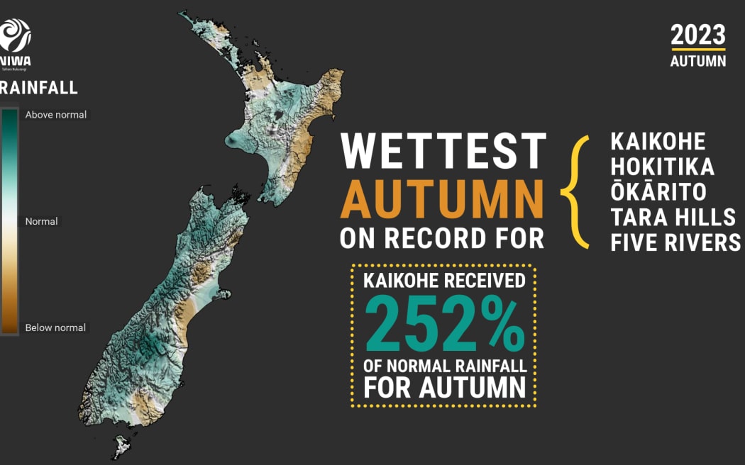
Rainfall was also well above normal average and 149 percent of normal for Northland, Auckland, Waikato, Bay of Plenty, Taranaki, parts of Manawatū-Whanganui, Wellington, Tasman, Nelson, northern Marlborough, West Coast, inland Otago and western Southland.
At the end of May, soils were wetter than normal for parts of Gisborne, Manawatū Whanganui, northern Marlborough, eastern Canterbury near Christchurch, and inland Otago.
Drier than normal soils were recorded in coastal parts of North Otago and South Canterbury.
Other May statistics:
- The highest temperature was 27.0°C, observed at Waiau on 3 May
- The lowest temperature was -5.2°C, observed at Middlemarch on 16 May
- The highest 1-day rainfall was 241 mm, recorded at Milford Sound on 2 May
- The highest wind gust was 169kmh, observed at Secretary Island on 10 May, and South West Cape on 26 May
- Of the six main centres in May 2023, Auckland was the warmest, Tauranga was the wettest and sunniest, Christchurch was the coolest and driest, and Wellington was the least sunny
- Of the available, regularly reporting sunshine observation sites, the sunniest four locations in 2023 so far are Taranaki (1101 hours), Central Otago (1100 hours), Mackenzie Basin (1096 hours) and West Coast (1060 hours)
Autumn as a whole
Autumn was characterised by periods of warm and wet weather. Photo:
Overall, the nationwide average temperature for autumn was 14.5C, well above average.
"Autumn 2023 was characterised by higher than normal mean sea level pressure (MSLP) east of Aotearoa New Zealand and lower than normal MSLP over New Zealand and the Tasman Sea. This generally resulted in more northeasterly winds than normal, bringing moist air from the tropics and sub-tropics across New Zealand, resulting in periods of wet and warm weather," NIWA said.
"The season saw a transition from a long-term La Niña pattern to an ENSO-neutral state, allowing for some variability in the monthly air flow patterns. While March saw more westerly winds than normal, both April and May returned to northerly-quarter air flow anomalies, more typical of a La Niña regime."
An ongoing marine heatwave event contributed to the unusual warmth.
"Overall, the most impactful event during the season was an atmospheric river originating in the tropics that brought heavy rain to large swathes of the country during approximately the first 10 days of May. The atmospheric river varied in strength and location during this time, but nevertheless delivered periods of heavy rainfall and thunderstorms to much of the North Island and the western and northern South Island."
Despite that, there were hints of colder months to come.
They included 21 March when snow fell to approximately 800 metres above sea level across parts of the lower South Island, NIWA said.
Another incident was 11 May, when a powerful cold front brought the coldest day since October 2022 for large parts of the South Island and snow down to around 400 metres for parts of Southland, Queenstown-Lakes District, and the Mackenzie Basin, NIWA said.
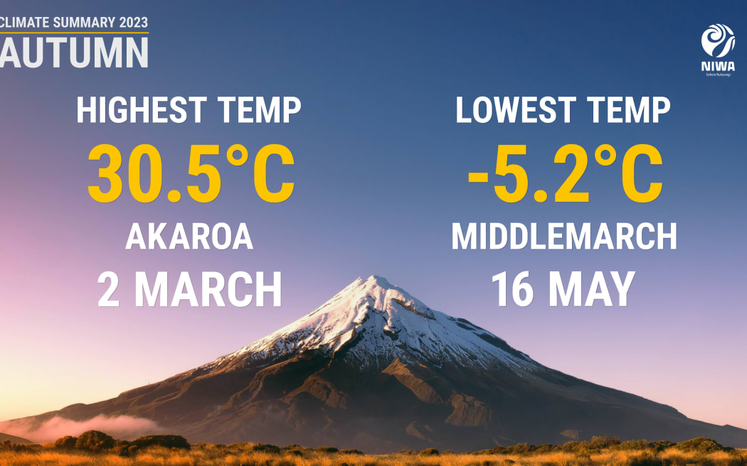
Temperature extremes throughout Autumn. Photo: Supplied / NIWA