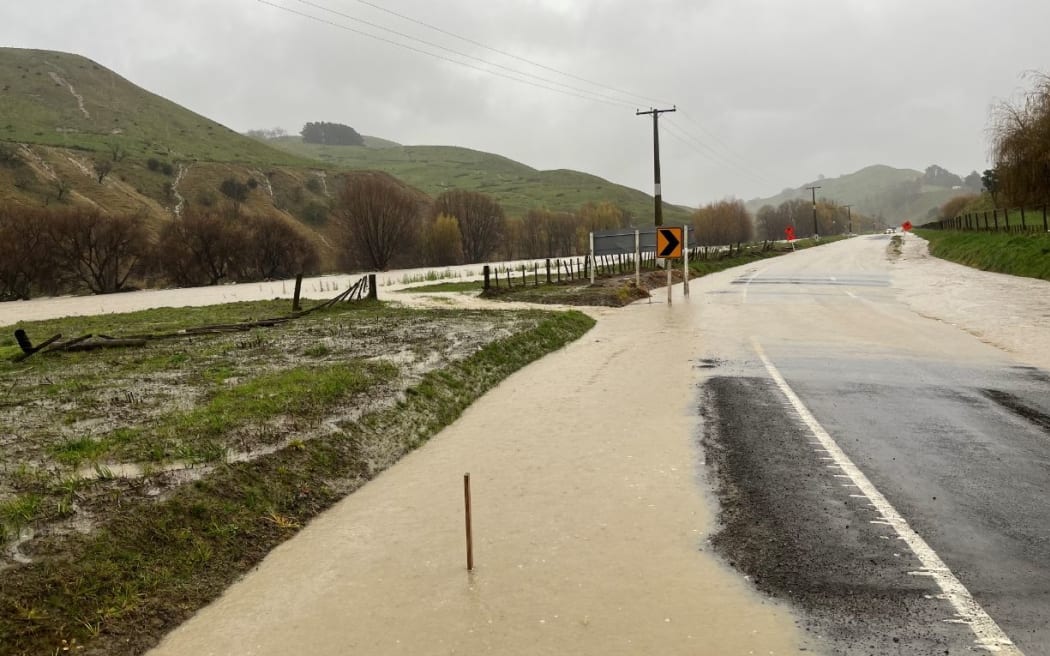
Flooding on State Highway 2 in Otoko, west of Te Karaka, in Tairāwhiti District. Photo: NZ Police
The weather forecast for Tai Rāwhiti / Gisborne has been upgraded to the highest heavy rain warning level with residents in the Gisborne town of Te Karaka being asked to evacuate their homes.
MetService has upgraded the alert level for flooding in the Tai Rāwhiti / Gisborne region from orange to the highest alert level, red until midday Sunday.
It is forecasting a prolonged period of rain which would be heavy at times with 200-300mm of rain expected about and north of Tolaga Bay, up to 150mm about the ranges and up to 100mm in coastal areas south of Tolaga Bay.
The rain was expected to cause dangerous river conditions and significant flooding, with slips and flooding likely to disrupt travel, making some roads impassable and potentially isolating some communities, the MetService warning said.
Tairāwhiti Civil Defence said it had activated and had a meeting with emergency services and other agencies on Thursday afternoon.
It said rivers were high and rising and people in low lying areas should not wait for official evacuations, and should leave if they felt unsafe.
House of Breakthrough and Te Poho-o-Rawiri Marae were open as evacuation centres, it said.
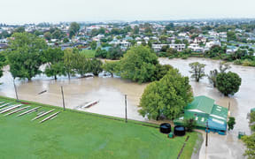
Residents in Te Karaka have been asked to evacuate as the Waipaoa River topped 7.5 metres and Tairāwhiti Civil Defence says Te Karaka Area School is an evacuation centre.
Chief fire officer Jamie Simpson said many areas that would need to be evacuated were already empty following Cyclone Gabrielle but anyone who did need to evacuate should do so during daylight hours.
Tairāwhiti Civil Defence said slips and flooding had been reported and 61 roads in the region were closed or restricted.
State Highway 35 around the cape from Gisborne to Ruatoria is now closed, as is the inland route SH2 between Ormond and Matawai. Highway road closures would be reviewed at first light on Friday, it said.
SH2 connecting Napier and Gisborne was set to close at 5pm at Wairoa.
Eastern District Police said flooding was making driving conditions dangerous in many areas and they were assisting on the roads.
They urged people to avoid any unnecessary travel and to report any slips or flooded areas.
GISBORNE SEVERE WEATHER - 3:10PM
— Waka Kotahi NZTA Central North Island (@WakaKotahiCNI) June 22, 2023
Due to flooding, the following roads are now CLOSED:
• SH2 Matawai to Ormond
• SH35 Okitu to Ruatoria
Please avoid the area and delay your journey. ^AP pic.twitter.com/3eGI786IoY
Gisborne's Te Poho o Rawiri marae is gearing up to receive evacuated residents.
Marae chair Harata Gibson said they were ready to accept people from anywhere, not just Te Karaka, where evacuations had been ordered by Civil Defence.
"We've only just received the official notice from Civil Defence, although our people were advised early this morning that it would be best for them to make the decision.
"Yeah, the pā is just gearing up to receive whānau who need shelter."
Tolaga Bay holiday park manager said Dion Milner the place was waterlogged and there was nowhere for the rain to go.
The Ūawa river was at about 8 metres, and while people were not evacuating yet, Dion Milner said he feared the worst was yet to come.
"Everything's sort of okay at the moment, but if they're predicting what we're predicting with this other load coming, it's gonna be interesting."
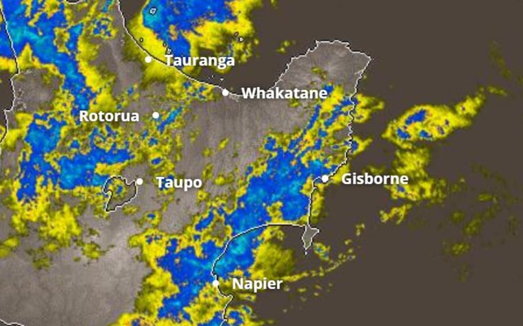
The MetService rain radar at 2.50pm on 22 June 2023. Photo: Screenshot / MetService
The heavy rain has already closed roads and brought down slips and Greg Shelton from Uawa Civil Defence said river levels were rising.
"Our concern is with the rain with heavy downpours we get a lot of flooding, not river related, just roads, infrastructure is probably starting to fail us now just land starting to move, culverts back up, that kind of thing."
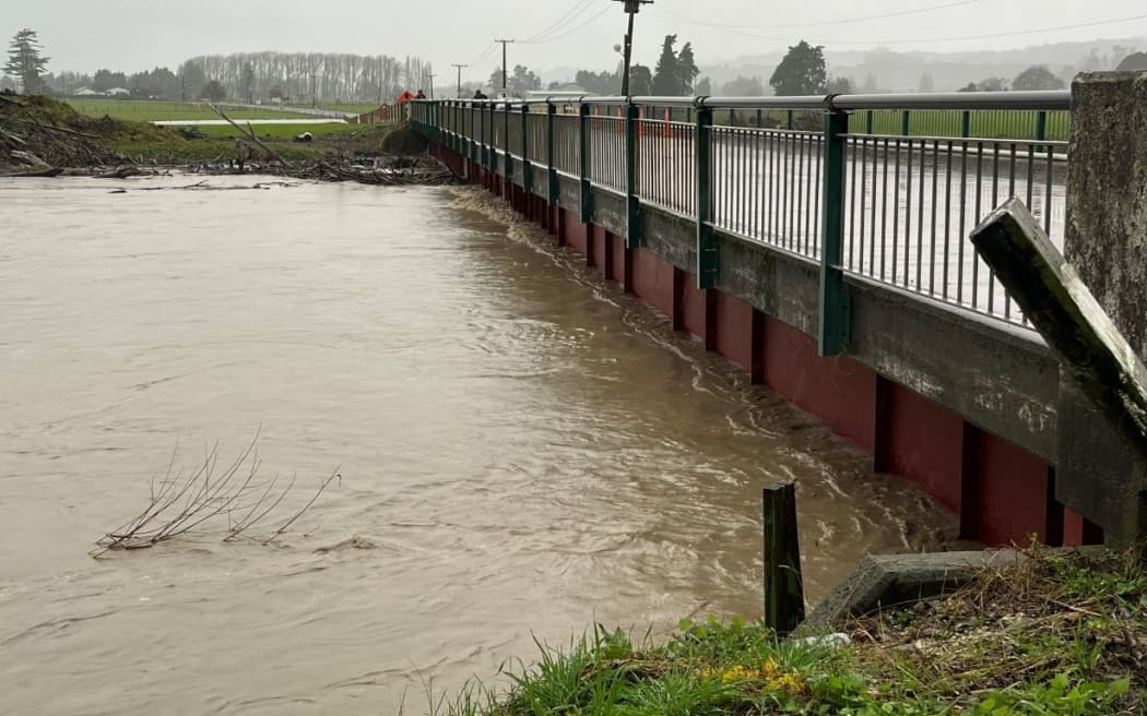
Bridge on Whatatutu Road, just off State Highway 2, north of Te Karaka. Photo: NZ Police
Bridge on Whatatutu Road, just off State Highway 2, north of Te Karaka.
There had not yet been any evacuations in Tologa Bay, as most people in at-risk areas relocated after Cyclone Gabrielle, he said.
MetService meteorologist Andrew James told Midday Report a prolonged period of rain which would be heavy at times was forecast for Tai Rāwhiti / Gisborne.
"There's a burst today, it's still raining tomorrow, another burst of heavy rain on Saturday expecting about 250 to 350 millimetres of rain in that northern part of the region over that time."
More than 220mm of rain had fallen in the Raukumura Ranges by midday Thursday, with 50-60mm having fallen at Gisborne Airport, he said.
Heavy rain warnings are also in place Coromandel Peninsula and Bay of Plenty west of Te Puke until 3pm on Friday with up to 160mm expected to fall, The Ruahine Range and Hawke's Bay from SH5 southwards until midnight Saturday with up to 150mm of rain forecast and Marlborough south of Ward until 3pm on Saturday with up to 250mm forecast.
Meanwhile, there has been heavy rain in Hawke's Bay, and more is forecast.
There are reports on social media of flooding in Eskdale, Puketitiri and Maraekakaho.
Napier City Council said river levels were rising, but is at this stage were not expected to spill over stop banks.
Hawke's Bay Civil Defence was monitoring the situation, and the emergency management group was meeting with key authorities this afternoon, it said.