
(File photo.) Photo: 123RF
MetService is warning parts of the country to expect gale northwesterlies and heavy rain as an intense trough of low pressure moves over the motu overnight on Sunday and into Monday.
Strong wind watches are in place for the Canterbury Plains and Marlborough Monday.
"This is an unseasonably cold outbreak, and snow may settle to around 1000 metres over Fiordland and the ranges of Otago during Monday, and in addition large southwest swells are expected over the west and south coasts of the South Island from later Monday," MetService forecasters said.
A trough is expected to bring a period of heavy rain and gale northwesterlies to western parts of both islands, followed by heavy showers and thunderstorms across southern and central New Zealand in a cold west to southwest flow.
It has issued orange rain warnings overnight until Monday morning for Fiordland north of Doubtful Sound, the Otago headwaters, the Tararua Range and Mt Taranaki.
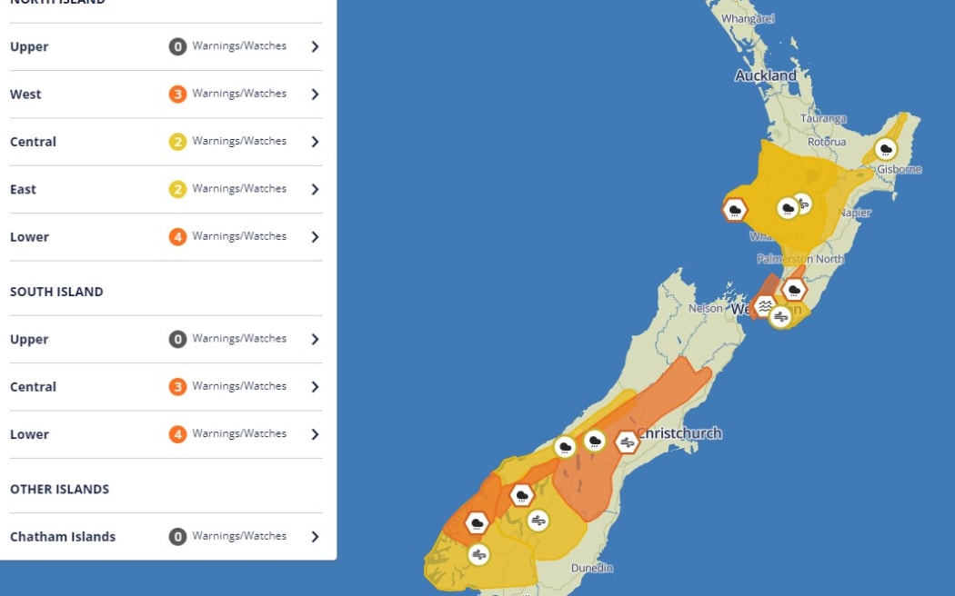
MetService weather warnings for Sunday into Monday. Photo: MetService
Already this weekend there has been heavy rain in parts of both the North and South islands, as well as strong winds and fluctuating temperatures.
⚠Severe Weather Update⚠
— MetService (@MetService) March 2, 2024
An intense trough of low pressure is expected to bring gale northwesterlies and heavy rain on Monday
Some rain and wind watches about the South Island have been upgraded to Orange Warnings
Watches have been added for the North Island as… pic.twitter.com/QctGeQ8drS
Heavy rain watches are in place for the Westland ranges, the headwaters of Canterbury lakes and rivers from Arthurs Pass southwards, central and western areas of the North Island and the ranges of eastern Bay of Plenty and Tairāwhiti.
The trough will be accompanied by widespread strong or gale northwesterly winds, which will ease in the south on Monday morning but affect central areas until Tuesday afternoon.
Strong wind watches are also in force for Fiordland, inland Southland and Otago, and central and southern parts of the North Island, gusting 100 km/h in exposed places.
For the most up to date changes, please check the MetService warnings page.
Drivers in the lower North Island are also being told to brace for challenging conditions on the roads tomorrow.
The Transport Agency Waka Kotahi said drivers on exposed routes such as State Highway 2 on the Remutaka Hill and the Wainui Saddle on State Highway 1's Transmission Gully should take extra care because of the severe northwest winds.
The bad weather is likely to affect peak travel times tomorrow afternoon.