By David Hill, Local Democracy Reporter
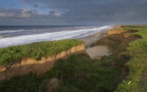
![Leithfield Beach . . . The community of 245 houses could be under threat from future sea level rise. Photo: David Hill / North Canterbury News [LDR single use only]](https://media.rnztools.nz/rnz/image/upload/s--Bhw86VKH--/ar_16:10,c_fill,f_auto,g_auto,q_auto,w_1050/v1705440487/4KW9R17_Hur1078LDRcoastal1_scaled_jpg)
The community of 245 houses could be under threat from future sea level rise. Photo: David Hill / North Canterbury News
Managed retreat is being considered as an option for a Canterbury coastal community facing the threat of rising sea levels.
The Hurunui District Council adopted a coastal adaptation plan for the Leithfield Beach community, south of Amberley, last month.
While managed retreat was an option in the future, mayor Marie Black said the council would be guided by the residents.
The plan addresses the threat of coastal erosion, flooding and sea level rise and sets out points to discuss on the next action, she said.
It was the result of nearly four years of engagement with the Leithfield Beach community.
Leithfield Beach is a village of 245 houses and a beach holiday park.
Managed retreat involves relocating people, assets, activities, and taonga from flood-prone or dangerous locations.
''This has been a long journey with our beach communities and I have really appreciated the community giving their insights, particularly those who have been there a long time,'' Black said.
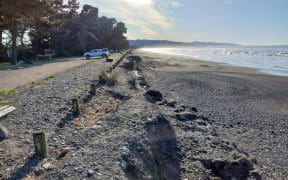
![The Hurunui District Council has adopted a coastal adaptation plan for Leithfield Beach. Photo: David Hill / North Canterbury News [LDR single use only]](https://media.rnztools.nz/rnz/image/upload/s--5AjhNEy1--/ar_16:10,c_fill,f_auto,g_auto,q_auto,w_1050/v1705440487/4KW9R17_Hur1078LDRcoastal3_scaled_jpg)
The Hurunui District Council has adopted a coastal adaptation plan for Leithfield Beach. Photo: David Hill / North Canterbury News
Drop-in sessions were held for the Leithfield community early in the process.
It allowed residents to bring in old photos from past weather events and share their experiences of past flooding, dry periods and coastal erosion to complement the science, Black said.
The plan provided talking points for the community as its considers what to do next.
Future trigger points included a series of major flood events where major capital works were required, an event requiring more than 30 houses to be rebuilt, or houses were unable to insured.
Possible actions included building a bund to protect the houses from the sea, introducing coastal protection measures or managed retreat.
A report to last month's council meeting suggested the bund wall would surround the settlement to the north, east and south, to protect it from fluvial and surface flooding.
It proposed the bund would be around 1.2 metres high and 1.9 kilometres long.
More engagement was needed with the community before a targeted rate for flood protection work was considered.
The Leithfield Beach plan is the second one adopted by the council, after an Amberley Beach plan was adopted in June last year.
The council was working on plans for the Gore Bay, Motunau Beach and Conway Flat / Claverley beach communities.
The process started in 2020 with a ''Coastal Conversations'' project alongside the five beach communities.
It was assisted by a web-based tool, ''Coastal Adaptation Explorer'', developed by international technology firm Jacobs.
The web-based tool won an award from the United Kingdom's Environment Agency last year.
LDR is local body journalism co-funded by RNZ and NZ On Air.