
by Veronika Meduna
'In this area, the gorge cuts through a sequence of rocks that span the entire geological history of New Zealand from about 90 million years ago right through to the present day.' _James Crampton
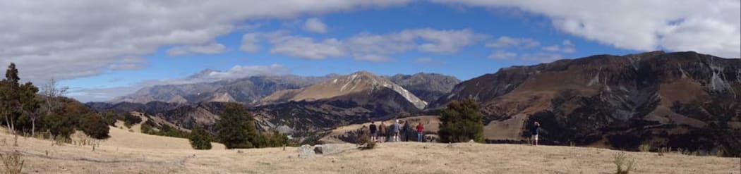
Looking out across the inland Kaikouras: Mount Tapuae-o-Uenuku (the highest peak in the background, on the left) was once the belly of a volcano, some 90 million years ago, and about 10 kilometres under ground. It has since been uplifted by the Clarence Fault and eroded. Photo: RNZ / Veronika Meduna
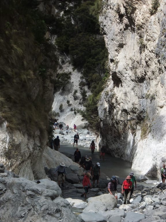
Mead Stream Gorge, about halfway between Blenheim and Kaikoura, is one of New Zealand’s geological wonderlands.
Geologists come from all over the globe to study the exposed rocks and the gorge is possibly the only place in New Zealand where you can travel through 90 million years of geological history in one day.
At the start of their annual week-long field trip to study the Mead Stream Gorge, GNS Science geologists and the Murray family organised a guided tour for the public to raise funds for the Kekerengu community. Photo: James Crampton
Geologists and paleontologists from GNS Science have led field work in the gorge for several decades, working closely with the Murray family, who own Bluff Station inland from Kekerengu on the Marlborough coast.
Paleontologist James Crampton says the gorge is one of the most accessible in the region, but also represents the most continuous geological record, spanning from the slow drowning of the Zealandia landmass following its split from Gondwana, through the geological boundary that marks the demise of the dinosaurs, and on to a period of mountain uplift that continues today.
'The rocks lowest down are from a time when there was still tectonic movement going on and New Zealand was breaking off Gondwana, splitting away and drifting into the South Pacific by continental drift. Then, for a long time there was no tectonic activity and New Zealand gradually sank.'
Further up the gorge a layer of huge boulders provides evidence for the start of a new tectonic phase and mountain uplift when the Alpine Fault formed, about 25 to 35 million years, and finally, right at the top of the gorge, is the active Clarence Fault, one of the country’s fastest moving faults.
One of the significant – albeit perhaps least obvious – sightseeing stops in the gorge is the geological boundary layer that marks the end of the Cretaceous epoch and the extinction of the dinosaurs, together with about half of all other creatures that lived at the time.
It was the second largest extinction event of all times, but all that remains of it today is a thin dark sliver of clay, measuring a few centimetres, that marks the moment when a meteorite hit Earth and covered the planet in dust. This layer is commonly known as the K-T boundary (T stands for the Tertiary, and K comes from Kreidezeit, the German term for the Cretaceous).
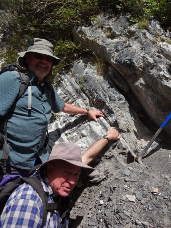
Chris Hollis, left, and Percy Strong from GNS Science are holding on to the K-T boundary layer. Photo: RNZ / Veronika Meduna
Chris Hollis, at GNS Science, says the K-T boundary at Mead Stream was very difficult to pinpoint, and represents one of only two places in the world with an unusual signature of the meteorite impact. Two types of evidence usually identify the boundary: a high level of Iridium (an element that is extremely rare in the Earth’s crust, but abundant in most asteroids and comets) and the sudden extinction of microscopic organisms called foraminifera, or forams for short. “This Iridium anomaly in this case is found only in the burrows in the top of the Cretaceous,” he says.
'What’s happened is that the meteroite hit the Earth, the dust cloud enveloped the planet, the Iridium-rich clay settled down through the oceans, fell on the seafloor, filled the burrows and all the things inside the burrows died. Then it was swept clean by some current, possible a tsunami from the impact that swept the surface clean so there’s only normal clay deposited afterwards and all the Iridium, all the evidence of the impact, is actually in the burrows in the top of the Cretaceous.' _Chris Hollis
Further up the gorge, a layer of conglomerates – rocks that are made of lots of cobbles and pebbles – signify the beginning of a new period of tectonic activity and mountain uplift. James Crampton says this marks the instant when the modern plate boundary and mountain uplift started in this area. “Tectonic activity suddenly switched on here, mountains started going up really fast and eroding, and all this gravel was falling into deep water off the edge of the mountains – exactly what’s still happening off Kaikoura today with the Kaikoura Canyon.”
Right at the top, GNS Science earthquake geologist Russ van Dissen studies the Clarence Fault, one of a cluster of active faults that branch off the Alpine Fault and trend northeast through Marlborough and towards the North Island. “It’s one of the four big faults of the Marlborough fault system,” he says. “This fault zone transfers the motion from the subduction zone in the North Island, and as we move south these four faults distribute the strain and then all that gets dumped down onto the Alpine Fault further to the south and on the west coast of the South Island.”
The Clarence Fault moves about five millimetres per year and is one of several fault lines Russ van Dissen studies in an effort to piece together the region’s earthquake history. He says the Clarence Fault has produced large earthquakes in the past, on average every 2000 years, with the last one about 1700 years ago. “If we do that for all major faults … that all gets put into the building code. One of the outcomes of the work we’re doing here is how to prescribe the appropriate earthquake loadings for buildings.”
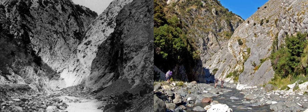
The image on the left was taken in 1885 by geologist and photographer Alexander McKay (who made his own lenses by grinding down bottle ends). James Crampton returned to the same spot in 2008. Photo: James Crampton
The team also explored a layer that represents the Paleocene-Eocene Thermal Maximum, or PETM. During this episode, some 55 million years ago, the Earth warmed rapidly and went through a major climate change and extinction event. Our Changing World will feature this part of the research next month.

