

Last week in southern Mexico Hurricane Otis made landfall near the city of Acapulco as a category five hurricane. With wind speeds estimated at around 266 kph (165 mph) it caused huge amounts of damage and loss of life.
In part because there was so little warning.
Just 24 hours beforehand the US National Hurricane Centre modelling of then tropical storm Otis predicted max winds of about 112 kph (70 mph).
But the rapid and unexpected intensification of Otis caught everyone off guard, including the weather models.
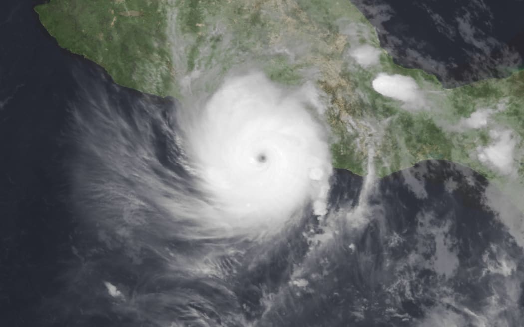
Hurricane Otis over Mexico. Photo: US National Oceanic and Atmospheric Administration
Follow Our Changing World on Apple Podcasts, Spotify, Stitcher, iHeartRADIO, Google Podcasts, RadioPublic or wherever you listen to your podcasts
Is the forecasting game changing?

Dr Tristan Meyers. Photo: NIWA
“You can never really attribute, you know, one single weather event to climate change. It’s very difficult to do that,” says NIWA meteorologist Tristan Meyers. But, he says, different recent extreme weather events in New Zealand do have the “fingerprints of climate change” all over them.
As part of his job, Tristan works on a number of different forecasts: from on demand ‘now-casts’ to look a few hours ahead – maybe to help Fire and Emergency New Zealand deal with spreading fires – through to seasonal forecasts across a few months to help those dependent on the weather for their livelihoods prepare for what’s to come.
But the impacts of climate change are making his job trickier.
El Niño is here
There’s a large patch of ocean in the Eastern Pacific along the equator where sea surface temperatures are monitored closely. Think of it as extending out from Ecuador in South America, into the middle of the Pacific.
When this patch of ocean is warmer than normal, and the air above the ocean responds, that’s when the El Niño Southern Oscillation is in effect. Wind and ocean currents change, and when these changes spread out across the Pacific, it generally means more westerly winds for Aotearoa.
With El Niño officially declared as an important climate driver for this summer season, we can look at past seasons to forecast what might be coming: westerly winds that bring rain to the west coast but a drier outlook for the east of the country.
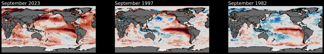
A comparison of sea-surface temperature anomalies for three El Niño periods: from left, September 2023, September 1997 and September 1982. The large red blob in the Pacific is characteristic of El Niño, however, 2023 is also warmer than average nearly everywhere – this El Niño brings “uncharted waters”. Photo: Ben Noll / NIWA
Overlapping climate drivers
But this year El Niño is not alone. In the Indian ocean a second climate driver that impacts New Zealand weather has popped its head up. The positive Indian Ocean Dipole means a cooler than normal patch of ocean off the northwest of Australia – an area where some of the moisture that funnels down to New Zealand comes from. Cooler ocean means less evaporation, means less moisture in the air, could mean less rainfall. The last time this was in effect, in 2019/2020, there was widespread drought across New Zealand.
And of course… climate change
But add to the mix unprecedented global temperatures, including warmer than average sea surface temperatures in the ocean surrounding New Zealand, and seasonal forecasting becomes much tougher.
In general, the combination of El Niño and the positive Indian Ocean Dipole should mean less large rainfall events for the north of the country. But already the out-of-season Cyclone Lola, the earliest category five cyclone on record for the southern hemisphere, has bucked the trend.
“It’s a very, very tricky period to be forecasting and really we’re in uncharted waters at the moment,” says Tristan.
Listen to the episode to learn more about how forecasters use physical models, historical data and machine learning to try to look at what might be coming our way, and the things we should all prepare for in an El Niño year.
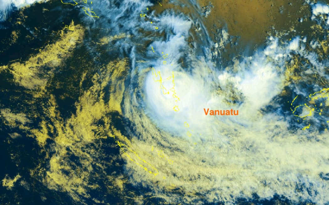
Tropical Cyclone Lola over Vanuatu as seen in satellite imagery at 11am (NZ time) on 25 October, 2023. Photo: Supplied / Vanuatu Meteorology
To learn more:
-
For more about how cyclones form and grow, and what is predicted to happen in a warming world listen to Blooming Cyclones.
-
The Detail also covered what El Niño might mean for our summertime weather, and for fruit and veggie prices at the supermarkets.

